After the monsoon rains retreat, the valleys of central Nepal look freshly washed. Terraced hillsides glow green and gold, the Budhi Gandaki river runs loud and milky-grey, and snow peaks that were hidden for months slowly appear above the cloud line. Few places show this seasonal change as dramatically as the Manaslu Circuit Trek, a loop around the 8,163-metre Mount Manaslu that climbs from subtropical forest to the stark, wind-scoured Larkya La Pass.
Two questions come up again and again among travellers researching this route. When is the best time to go, and can a first-time trekker really do it? The short answers: autumn (September to November) is one of the two main trekking seasons, and October is the most popular month for its generally settled conditions. And yes, a well-prepared beginner may be able to complete the Manaslu Circuit Trek, but it is a demanding high-altitude trek, not an easy introductory walk. The rest of this guide explains what that means in practice.
Detail | Overview |
|---|---|
Location | Manaslu region, Gorkha district, north-central Nepal |
Typical duration | Roughly 12 to 16 days walking and travelling, depending on route, transport and acclimatization (itinerary-dependent, not fixed) |
Highest point | Larkya La Pass, approximately 5,106 m (some sources give slightly higher figures) |
Best seasons | Autumn (September to November) and spring (March to May) |
Difficulty | Demanding. Long days, high altitude and a remote setting |
Beginner friendly? | Possible with solid preparation, a gradual itinerary and qualified support. Not an easy first trek |
Permits | Restricted Area Permit plus conservation-area permits, arranged through a registered agency |
Guide | A licensed guide is required in the restricted section |
Highlights | Himalayan panoramas, Tibetan-influenced culture, suspension bridges, monasteries, remote alpine terrain |
Autumn follows the summer monsoon, and that timing shapes almost everything about the experience. Dust has been rinsed from the air, rivers are full, and the landscape is at its most vivid. It is also a festival season in Nepal, so you may see local celebrations on the journey to and from the trailhead. Autumn is not a guarantee of perfect weather, but it is generally the season when more things go right.
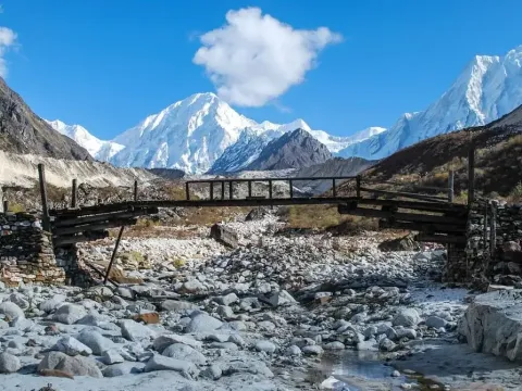
Once the monsoon moisture clears, visibility often improves. On a good morning you may see Manaslu, Himalchuli, Ngadi Chuli and Himlung Himal rising above the valley walls, with golden light on the summits at sunrise. Photographers tend to love the contrast between green lower slopes and white peaks above. Cloud can still gather in the afternoons, especially early in the season, so the best views are often early in the day. Treat clear skies as a bonus, not a promise.
As the rains fade, trails generally dry out and become firmer underfoot. Streams are easier to cross, and the transport to the trailhead is usually less disrupted than in mid-summer. That said, the monsoon does not stop on a fixed date. Late rain, mud, leeches at lower elevations, landslides and washed-out sections of trail can still occur in September and sometimes into early October. Flexibility in your schedule is the best protection.
The higher valley is home to communities with strong Tibetan Buddhist influences. Along the trail you will pass long mani walls with carved prayer stones, kani entrance gates, prayer wheels, fluttering prayer flags and monasteries such as Pungyen Gompa near Samagaun and Ribung Gompa. Walk to the left of mani walls and chortens, as local custom dictates, ask before photographing people or religious ceremonies, and accept the simple hospitality of tea houses with the understanding that you are a guest in someone's home village.
Compared with Everest Base Camp or the Annapurna Circuit, the Manaslu Circuit sees fewer trekkers. Restricted-area rules and the long drive to the trailhead keep numbers lower, and upper villages feel quieter and more traditional. Remember, though, that autumn is peak season. In October, popular stops such as Samagaun and Dharamsala can fill up, so advance booking through your agency is wise.
The season moves from the tail of the monsoon, through a stable middle period, into early winter. Weather in the Himalaya depends heavily on elevation: a warm afternoon in the lower valley at around 700 to 1,000 metres can sit alongside freezing nights near 4,500 metres. Conditions also vary from year to year, so treat the patterns below as general tendencies and not as forecasts. The safest approach is to check current conditions with your agency close to departure.
Early September often still feels like monsoon. Expect lingering rain, cloud cover and humid, warm weather in the lower valley. The upside is lush green scenery, running waterfalls and fewer trekkers.
The trade-offs are real. Trails can be muddy and slippery, landslides can block roads or paths, and views are less dependable. Some trekkers also meet leeches in the damp lower forests. If you choose September, build a few buffer days into your plan, carry reliable rain gear and a pack cover, and accept that you may face weather delays. It can be rewarding, but it is less predictable than most October windows. Late September typically improves as the rains taper off.
October is widely regarded as the sweet spot. Conditions are often settled, with generally good visibility and comfortable walking temperatures during the day, while nights are cold at altitude and below freezing near the pass. Days tend to be sunny at lower elevations, though cloud can build in the afternoon.
Because of this, demand peaks. Experienced guides, tea house beds in high villages and permit slots are more likely to be in short supply, so booking early makes sense. Even in October, no one can promise uninterrupted sunshine or guaranteed clear views, and an early snowfall at high elevation is possible.
November can bring crisp, clear skies and excellent visibility when conditions cooperate, along with thinner crowds as the season winds down. But it also brings noticeably colder temperatures. Mornings and evenings are sharp, nights at high camps can be severely cold, and some tea houses at the upper end may reduce services as winter approaches.
Snow and ice near Larkya La become more likely, which can make the crossing slower, colder and sometimes impossible on a given day. Daylight is shorter, so early starts matter. If you plan for November, bring a warmer sleeping bag and insulation than you would for October, allow flexibility, and check pass conditions before committing to the crossing.
Factor | September | October | November |
|---|---|---|---|
Weather reliability | Least predictable. Rain and cloud common early on | Generally the most settled | Often stable, but cold and a higher chance of snow at height |
Mountain visibility | Variable, clearing late in the month | Often good, especially mornings | Often excellent when skies are clear |
Trail conditions | Muddy, slippery, landslide risk | Mostly dry and firm | Dry lower down, snow or ice possible near the pass |
Temperature | Warm and humid low, cool high | Mild days, cold nights | Cold days at height, very cold nights |
Crowd levels | Lighter | Busiest | Moderate to light, falling through the month |
Best suited to | Flexible, rain-tolerant trekkers who value green scenery and quiet | Most first-timers who prefer the most balanced conditions | Experienced or cold-tolerant trekkers who prioritise views and space |
For most people, mid-October is a sensible default, but it is not the best choice for everyone. If you dislike crowds and have schedule flexibility, late September or early November may suit you. If you feel cold easily or want maximum margin on the pass, October is usually the safer bet.
Yes, a first-time trekker can potentially complete the Manaslu Circuit Trek, provided they train properly, choose an itinerary with enough acclimatization time, travel with a qualified guide and understand the demands of altitude. Being a beginner does not automatically rule you out. But this is a high-altitude trek lasting two weeks or more in a remote area, not a gentle introduction to trekking. Honest self-assessment matters more than enthusiasm.
There is no universal answer. Everest Base Camp reaches about 5,364 metres, with Kala Patthar at roughly 5,545 metres, so it goes higher overall and is more heavily trafficked, with more lodges and services. The Manaslu Circuit tops out at about 5,106 metres but is more remote, has fewer facilities and includes a single, demanding pass crossing day. Some trekkers find Manaslu harder because of the logistics and remoteness; others find Everest harder because of the sustained altitude and crowds. Difficulty depends on your itinerary, acclimatization, fitness, season and how your body responds to altitude. Choose based on your preparation, not on rankings. If you want a longer high-altitude challenge in the Everest region, take a look at the Everest Three Passes Trek.
A good candidate typically enjoys long walking days, is willing to train for several weeks or months, accepts basic accommodation, listens to guides, and allows enough time to acclimatize. If you have never done a multi-day hike, a shorter or lower-altitude trek, such as a route below 4,000 metres in the Annapurna or Langtang region, can be a better first step, with Manaslu as a later goal. If you have a history of serious heart, lung or altitude problems, speak to your doctor before planning.
Difficulty is not just about distance. It combines duration, altitude, terrain, weather, remoteness and your own recovery. On this trek, the cumulative load of many days at altitude matters more than any single section, except for the pass.
As approximate figures, typical days run between five and eight hours of walking, with shorter days during acclimatization. Pass day can run eight to ten hours or longer. Distances are less meaningful than time, since steep sections and altitude slow your pace. Hours vary with route, weather, trail condition and your pace.
The trail climbs from roughly 700 metres at the start to about 3,500 metres at Samagaun, and to around 4,460 metres at Dharamsala, before crossing the pass. Gradual ascent, rest days and steady pacing are essential. Endurance helps you walk day after day, but it does not control how your body adapts to thin air.
The crossing demands an early start, often well before sunrise, because the pass is cold and wind increases later in the day. You may face snow, ice, steep sections and a long descent. Your guide will judge current conditions and may delay or cancel the attempt if safety requires it. For many trekkers it is the hardest and most memorable day of the entire trek.
Adapt this to your existing fitness, and ideally begin several weeks to a few months before departure:
A practical sign of readiness is being able to walk for five to six hours with a light pack on uneven, hilly ground, then repeat that for several days without being completely exhausted. If you can do that comfortably, your fitness is probably in a reasonable place. But fitness cannot eliminate altitude sickness risk. Very fit people get altitude illness, and less fit people sometimes do not.
Expect cold mornings, basic rooms and days when you feel slow. Walk at a steady, comfortable pace, do not race other groups, and accept that itinerary changes may be needed for safety. Patience is one of the most useful skills on this route.
Acute mountain sickness (AMS) can occur when you climb faster than your body can adapt. Rarer but serious forms, including high-altitude pulmonary oedema (HAPE) and high-altitude cerebral oedema (HACE), can become life-threatening. High-altitude trekking is never risk-free.
Watch for headache, nausea, dizziness, unusual fatigue and loss of appetite. Do not dismiss these as ordinary tiredness. Tell your guide early and honestly.
Ascend gradually and use the scheduled acclimatization days.
Avoid overexertion, especially on arrival at a new elevation.
Drink fluids according to thirst and keep well hydrated. Water alone does not prevent altitude sickness.
Discuss individual risks and any preventive medication, such as acetazolamide, with a doctor or travel-medicine specialist before you leave. Medication does not make a rapid ascent safe.
Report symptoms immediately rather than hiding them to keep up with the group.
If symptoms worsen, stop ascending and descend if advised. Severe breathlessness at rest, confusion, difficulty walking in a straight line, a persistent cough with fluid sounds, or severe headache that does not respond to rest need urgent action and descent where appropriate. Never ascend with worsening symptoms.
The trail changes character as it climbs. It begins in warm river valleys with forest, terraced fields, waterfalls and long suspension bridges over the Budhi Gandaki. Stone steps and village paths lead through settlements, and some sections are narrow and cut into steep hillsides, with exposed drops. Higher up, the valley opens into alpine terrain with pine and juniper forests, yak pastures and bare, rocky ground near Larkya La. Depending on the year, you may meet mud lower down and snow or ice higher up, and landslides can damage sections of trail.
Trekking poles, sturdy broken-in boots, awareness of weather and a qualified guide help with all of this. Your guide knows which sections are unstable, where to cross rivers and when to turn around.
Larkya La, at about 5,106 metres, links the Budhi Gandaki valley with the Marsyangdi side. Here is what to expect:
The crossing should never be treated as guaranteed, and it should never be attempted in unsafe conditions just to keep to a schedule. A realistic itinerary with spare days gives you the best chance of crossing safely, and appropriate equipment, including warm gloves, insulated boots, goggles or sunglasses and traction devices if recommended, matters more than speed.
Meals are served in tea houses, and menus are simple and filling. Common dishes include dal bhat (rice, lentil soup and vegetable curry, often with refills), fried or boiled rice, noodles, soups, potatoes, eggs, porridge, bread and tea. Variety shrinks and prices rise with altitude because everything is carried in, and menus and availability vary by village and season.
Carry some snacks you enjoy, such as nuts, chocolate or energy bars, because appetite can drop at altitude. Tell your agency about vegetarian, vegan, allergy or other dietary needs before departure so your guide can plan with the lodges. Eating freshly cooked vegetarian food is generally the safer choice in remote areas.
Expect basic mountain lodging: small twin rooms with simple beds and mattresses, shared bathrooms in most places, and a communal dining room, often heated by a stove in the evening. Rooms are unheated and can be very cold at higher elevations, so a good sleeping bag helps. Hot showers (often paid for), device charging and internet are available in some villages but are unreliable and sometimes unavailable higher up. Go with realistic expectations: this is simple, friendly hospitality, not luxury, and that is part of the experience.
The Manaslu region is a restricted area, so trekking independently is not allowed. You need the correct permits, arranged through a registered trekking agency (the Trekking Agencies' Association of Nepal lists member agencies), and you must trek with a licensed guide in the restricted section. Typical permits are:
On group size, published information is inconsistent. The traditional rule required a minimum of two trekkers, but several 2026 agency pages say that requirement was dropped in a March 2026 update, so a single trekker with a licensed guide may be allowed. Please confirm the current rule with the Department of Immigration or your agency before booking. The fees above come from trekking agencies, not official notices, so verify them against official sources. Treat anything specific to our own booking policies as company policy, not law.
Pack light, and favour layers, because you may carry a daypack while porters carry the main bag.
Moisture-wicking base layers (tops and bottoms)
Fleece or insulating mid-layer
Warm down or synthetic jacket for evenings and pass day
Waterproof and windproof jacket and over-trousers
Trekking trousers and a spare pair
Warm hat, buff, liner gloves and insulated gloves or mittens
Warm socks (several pairs)
Broken-in, waterproof trekking boots with good ankle support
Camp shoes or sandals
Trekking poles
Daypack of around 30 to 40 litres, with rain cover
Headlamp with spare batteries
Water bottles or hydration system
Sleeping bag rated for cold nights (often provided for rent, but check hygiene and warmth)
Sunglasses with strong UV protection
High-SPF sunscreen and lip balm
Personal medications and a basic first-aid kit, including blister care
Water treatment tablets or a filter
Toiletries, quick-dry towel and hand sanitiser
Passport and visa, plus copies
Permits (your agency usually handles these)
Travel insurance covering high-altitude trekking up to the pass and emergency helicopter evacuation
Cash in Nepalese rupees, because there are no reliable ATMs on the trail
Emergency contacts and a note of medical conditions
Skip unnecessary extras, since weight adds fatigue. Anything missing can usually be bought or rented in Kathmandu.
A good itinerary balances daily walking time, altitude gain, acclimatization, available lodging and weather contingency. A schedule that looks efficient on paper can become risky if it ignores how people actually adapt to altitude.
A realistic general range is about 12 to 16 days, including the drive from Kathmandu and back. Shorter schedules exist but compress acclimatization. The total depends on transport options, route variations, side trips such as Birendra Lake or Pungyen Gompa, and your arrival and departure plans. It is wise to add one or two spare days for weather and delays.
Acclimatization gives your body time to adjust to lower oxygen. A rest day at Samagaun, with an optional side hike up and back to a lower sleeping altitude, is a standard approach. Shortcuts and skipped rest days raise the risk of altitude illness, so avoid cutting them to save time.
Usually, yes. A longer, more flexible schedule gives first-time high-altitude trekkers shorter days, extra rest, more buffer for weather and a better chance of crossing Larkya La in good condition. There is no single itinerary that suits every trekker, so ask your agency to tailor the schedule to your experience and fitness.
Costs vary widely, so there is no single price. The main factors are:
Because components differ, ask for a written quotation that clearly lists what is included and excluded. Requesting a personalised quote from All Himalayan Treks gives you a figure based on your dates and requirements.
Choose dates according to your priorities and risk tolerance.
Book a qualified guide and a registered trekking agency.
Prepare physically before arriving in Nepal.
Carry suitable layers for changing temperatures.
Allow time for acclimatization and unexpected delays.
Check current trail, weather and pass conditions.
Keep cash for remote villages.
Follow local cultural practices and ask permission before photographing people.
Obtain suitable travel insurance.
Prioritise health and safety over completing the trek on a fixed date.
For the right person, yes. The Manaslu Circuit Trek offers big mountain scenery, living Himalayan culture and a quieter feel than Nepal's busiest trails, and autumn is a season when conditions often work in your favour. It rewards trekkers who train, travel with a qualified guide, respect altitude and stay flexible.
October is popular for its generally favourable conditions, while September offers greener scenery and fewer people with less predictable weather, and November offers crisp views and colder nights with more risk at the pass. Beginners can succeed here, but only with preparation and realistic expectations. Nobody can guarantee weather, views, safety or successful completion, and a good decision to turn back is part of good trekking.
A trek like this is easier to enjoy when the planning is right. Choosing dates, matching an itinerary to your fitness, arranging restricted-area permits and booking lodging in the right order all take local knowledge. This is true for beginners who need a gradual schedule and for experienced trekkers who want a particular route or season.
All Himalayan Treks can help with itinerary planning, licensed guide arrangements, permit coordination, accommodation planning and preparation advice.
Planning your Manaslu Circuit Trek in autumn? Contact All Himalayan Treks to discuss your preferred travel dates, trekking experience, fitness level and itinerary. Our team can help you plan a trekking experience that matches your interests and preparation.
It can be, for beginners who train well, choose a gradual itinerary, travel with a licensed guide and accept the realities of altitude. It is a demanding, remote, high-altitude trek, not an easy starter walk. If you have never done multi-day hiking, consider a lower-altitude trek first.
There is no single best month. October is the most popular for generally settled weather and good visibility. September is greener but wetter, and November is clear but colder with more snow risk at Larkya La. Spring (March to May) is the other main season.
Yes, October is widely considered one of the best months, with generally stable conditions and good mountain views. It is also the busiest, so book guides and lodging early. Weather can still change, and nights are cold at altitude, so no clear skies are guaranteed.
November is noticeably colder. Nights at high villages can fall well below freezing, and temperatures near Larkya La can be very low, especially before sunrise. Days can be sunny and pleasant lower down. Bring warm insulation, a suitable sleeping bag and quality gloves.
It is one of the hardest days of the trek. The crossing starts in darkness, climbs to about 5,106 metres in cold, thin air and is followed by a long, steep descent. Snow or wind can make it harder. Conditions are judged on the day, and the crossing is never guaranteed.
About 12 to 16 days including travel from Kathmandu, depending on route, transport, acclimatization stops and side trips. Beginners often benefit from the longer end of the range, plus a spare day for weather delays.
Yes. Because Manaslu is a restricted area, you must trek with a licensed guide arranged through a registered trekking agency. A guide also helps with route-finding, altitude monitoring, local culture and decisions about weather and the pass.
Typically the Manaslu Restricted Area Permit, the Manaslu Conservation Area Permit and the Annapurna Conservation Area Permit, plus a local entry fee. Your agency usually arranges these. Fees and group-size rules can change, so confirm current requirements with official sources before booking.
Start several weeks to a few months ahead with regular hiking, uphill walking, aerobic exercise, leg and core strength and practice walks with a loaded daypack. Build to consecutive long walking days. Fitness helps endurance, but it does not prevent altitude sickness.
Choose a policy that explicitly covers trekking to at least 5,200 metres, emergency helicopter evacuation, medical treatment and trip delay or cancellation. Read the exclusions carefully, since some policies limit altitude or require a guide. Keep policy details with you on the trail.


Our travel experts are ready to assist you with any questions.
Send us a message.Have a question before you book? Send your enquiry below and our travel experts will get back with the required information.